
Exercise 003
Which corner?
A post says a photo shows delays on Mill Road. The street scene and a district map tell a different story.
Briefing
This is a fictional scenario. The city, the streets, the shops and the account are all invented, and the images were drawn for this exercise. Everything you need is on this page.
Port Alder, a fictional city that uses UTC+2 all year, has a district called the Harbour Quarter. At 08:12 on Monday 12 October 2026, an account called @portalder_commuter posted the photo below with this caption:
Route 14 delayed again, stuck here on Mill Road.
A local transit blog wants to know where the photo was really taken, and whether the “Mill Road” claim is supported. The platform stripped the file’s metadata, so all you have is what the picture shows.
Extra context: the post was published at 08:12, but the caption does not say when the photo was taken. If it was taken shortly before posting, then at about 08:10 on that morning the sun in Port Alder was low in the east.
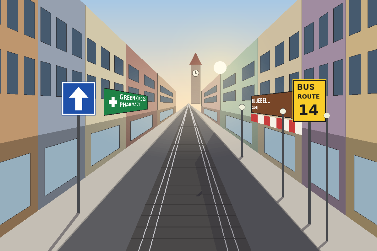
Open the street photo full size
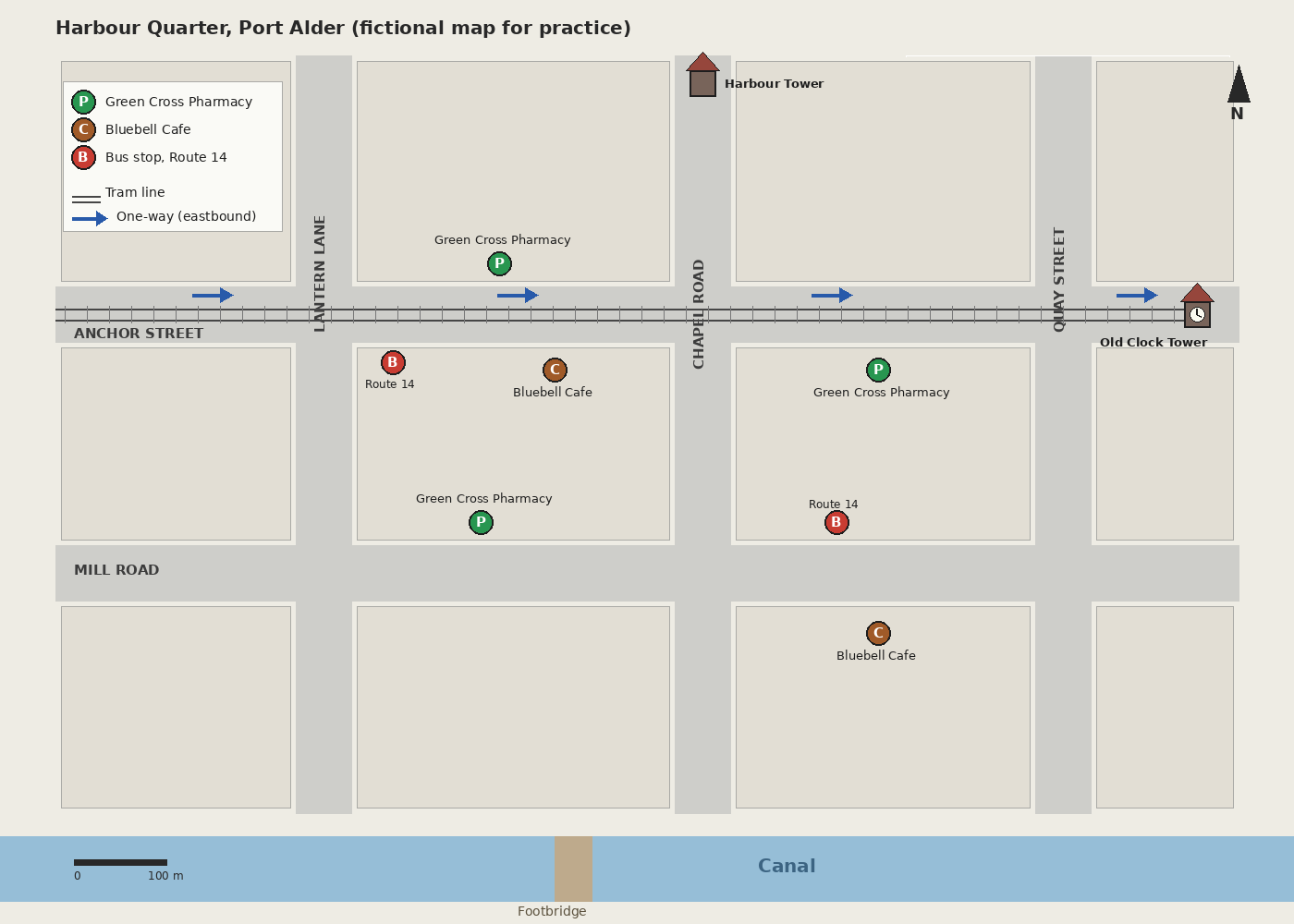
Open the district map full size
Tasks
- Collect the clues. List at least eight things you can see in the photo. Mark each as fixed, semi-fixed or movable, and note anything you cannot read or are unsure of.
- Choose a starting clue. Which clue narrows the search the most, and what does it rule out?
- Test the candidates. Using the map, list the candidate blocks and viewing directions that your starting clue leaves open, then test each one against all the other clues. Show your eliminations with reasons. Finish by naming the camera position and the direction it faces.
- Check the claims. (a) Is the photo on Mill Road? (b) Assuming the photo was taken shortly before it was posted, do the shadows agree with your answer, and how strong a check is that? (c) Does the photo show the delay the caption describes?
- Write your finding. In four sentences or fewer, give the location, the facing direction and your confidence, and say what extra evidence would raise it.
Hints
Hint 1 (task 2)
Start with the clue that can only be true of one street.
Hint 2 (task 3)
Left and right swap when you turn around. Write down which side of the road each sign is on, then work out which way you must face for the map to agree.
Hint 3 (task 3)
A missing clue can help as much as a visible one. Where would you expect to see a tower, and where would you not?
Solution
Solution (spoiler)
1. The clues.
- Fixed: tram rails in the road; a tower with a clock face at the far end, slightly right of centre; the buildings and their shopfronts.
- Semi-fixed: a Green Cross Pharmacy sign on the left; a Bluebell Cafe awning on the right; a bus stop sign for Route 14 on the right, nearest the camera; a one-way sign on the left with its arrow pointing ahead.
- Light: the sun is low and ahead of the camera, and the shadows fall toward the camera.
- Movable: there are no vehicles or people to use.
2. Starting clue. The tram rails. On the map only Anchor Street has a tram line, so this rules out Mill Road, Chapel Road, Lantern Lane and Quay Street. The pharmacy, cafe and bus stop signs each appear in more than one place, so they are weaker starting points.
3. Candidates. Test each candidate against every clue:
| Candidate (street, facing) | Tram rails | One-way arrow points ahead | Clock tower at the far end | Pharmacy on the left | Cafe and Route 14 stop on the right | Result |
|---|---|---|---|---|---|---|
| Anchor Street, east, at the Lantern Lane junction | Yes | Yes (the street is one-way eastbound) | Yes (the Old Clock Tower) | Yes (north-side pharmacy) | Yes | Match |
| Anchor Street, east, at the Chapel Road junction | Yes | Yes | Yes | No (the next pharmacy is on the right) | No (no cafe or stop ahead on the right) | Out |
| Anchor Street, west | Yes | No (the arrow would point toward the camera) | No (the clock tower is at the east end) | Sides swap, so no | Sides swap, so no | Out |
| Mill Road, east or west | No | No (two-way) | No | Depends on direction | The Route 14 stop is on the north side | Out |
| Chapel Road or Lantern Lane, either way | No | No | No clock face (Harbour Tower has none) | Not applicable | Not applicable | Out |
No single clue settles it. The rails reduce the search to Anchor Street, the one-way arrow and the clock tower give the direction, and the positions of the pharmacy, cafe and bus stop pick the block. The camera is on Anchor Street near the Lantern Lane junction, just west of the bus stop, facing east.
4. The claims.
- (a) Mill Road. The photo is not on Mill Road. It is on Anchor Street. The caption’s mention of Route 14 is plausible, because that route stops on both streets, but the photo does not support “Mill Road”.
- (b) Shadows. If the photo was taken shortly before the 08:12 post, a low sun in the east means a camera facing east looks toward the sun, so shadows fall toward the camera, as they do here. That is consistent with the answer, but it is a weak check. The post time does not prove when the photo was taken, and the photo alone does not fix the time of day. Facing west, the shadows would fall away from the camera, but that candidate is already out on the rails, the arrow and the tower. So the shadows add consistency, not new proof.
- (c) The delay. The photo shows no vehicles at all. That neither supports nor contradicts “stuck”: whatever caused a delay could be outside the frame, and one frame cannot show how long anything has lasted. Keep what you can see apart from what you infer.
Sample finding. The photo was taken on Anchor Street, near the Lantern Lane junction and facing east, not on Mill Road, because only Anchor Street has tram rails and the one-way arrow, clock tower, pharmacy, cafe and Route 14 stop all agree with that position and direction. The low sun and the shadows falling toward the camera are consistent with a morning photo facing east, but the capture time is not established, so they are only a weak check. Confidence is high for the street and direction and moderate for the exact spot within the block, and dated street-level imagery of the block, or another photo from the same account, would raise it.
Debrief
Habits this exercise is built to teach:
- Record before you interpret. List what you see first, and keep your guesses separate.
- Start with what cannot move. Rank clues by permanence and by how few places they fit.
- Test every candidate against every clue. One matching clue is a lead. A match on all of them is a result.
- Track left, right and facing direction. Many wrong answers come from reading the street backwards.
- Use missing evidence, and treat light as a consistency check. An absent tower can rule a place out. Shadows can support an answer but rarely prove it, especially when the time is uncertain.
- Keep observation apart from inference. An empty street does not prove or disprove a delay.
- State your confidence. Say what is certain, what is not, and what would raise it.
For more on this approach, read the blog post Where was this taken? Start with what cannot move.
Community walkthroughs
No community walkthroughs yet.
Submit your own
Write up your solution on your own site and send us the link. Every submission is reviewed by hand, and nothing is listed until it has been approved.